

Milan Radisics
How Water Shapes Earth
sequences from @water.shapes.earth project
Series examining the evolution of Earth’s waterways. Project shows where water comes from, how it is spreading, how beautifully shaping the planet and in the end, what lays ahead as water retreats. Millions of years of Earth’s evolution was compressed into one timeline.
Project Water.Shapes.Earth hopes to inspire awe, as well as provoke the public to face the destructive tendencies that we have toward our environment. The aerial point of view gives us the ability to observe our landscapes in the new light. Bordering between document and painting-like abstractions new perspective stimulate a process of thinking about something essential to our survival, something we often take for granted - until it’s gone.
The sequences from Water.Shapes.Earth project builded up into the photo essay of 12 pictures, is overall winner of 37th Hungarian Press Photo competititon, and received Award of Excellence in the 76. Pictures of the Year, in USA, Missouri.

Rose shaped ice crack
Unique rose shaped ice crack appear on the small Malsjön Lake in Marvikarnas naturreservat. Ackers, Sweden.
Ice crack as result of methane released during the first night of freezing, when bubbles broke up tiny ice. Later, when ice getting thicker shape getting more visible thanks to the contrast created by small bubbles inside the ice. It is around 20 meter wide in diameter and only seen from above.

Floating icebergs
Giant pieces of melting ice, remnants of the collapsing glacier, float motionlessly in the mud-coloured brown glacier lake until they vanish forever. Hoffellsjökull, Iceland. August 26. 2018.
Hoffellsjökull is an outlet glacier which flows from the ice cap of Vatnajökull, located in the southern region of Iceland. The glacier was greatest in size around one hundred years ago, and for the next fifty years, it drifted to the moraine ridge now situated in front of it. Local residents would drive up onto this ridge and fill trucks with glacial ice used for chilling fish, both onshore and at sea.
Due to climate changes, Hoffellsjökull has retreated a considerable distance. A deep lake is rapidly developing in the depression left behind. It will continue to grow as the glacier retreats.

Veins of Earth
Glacial river veins of Geirlandsá near Kirkjubaejarklaustur village, braiding their way through black volcanic sand, constantly creating new paths, intricately intertwined, and depositing a nutrients of various colors from melting glaciers. Iceland, Southern Region. August 28. 2018.
As the ice begins to melt, thousands of cool rivers run down with majestic elegance. Braided rivers consist of a network of river channels that carry vital nutrients for the ecosystem which they collect from the soil as they make their way from the glaciers towards the sea. The patterns are dynamic, changing gradually over time as the sediment slowly erodes to create new channels throughout the flat landscape.
These incredible spread throughout the vast flatlands of southern Iceland and only become visible from above as a result of stunning contrasts between the coloured water and the surrounding black desert.

Estuary of Affall River
VeinsWhere the Affall River meets the Atlantic Ocean, there is a confluence of three coloured tributaries that wind through various farmlands. Together they casually flow to the ocean across the black sandy beach. Landeyjar area, Southern Iceland. August 29. 2018
Affall is a small and clear spring water stream located just east of Hvolsvöllur, about 120 km from Reykjavik. Due to a connection with the Markarfljót River, the Affall was formerly very glacial colored. After blocking up the connection some years ago, it has become a clear spring water stream.

Stream patterns of Þjórsá River
Glacial river veins of Þjórsá River in Southern Region of Iceland, braiding their way through black volcanic sand, constantly creating new paths, intricately intertwined, and depositing a nutrients of various colors from melting glaciers. Iceland, Southern Region. August 29. 2018.
As the ice begins to melt, thousands of cool rivers run down with majestic elegance. Braided rivers consist of a network of river channels that carry vital nutrients for the ecosystem which they collect from the soil as they make their way from the glaciers towards the sea. The patterns are dynamic, changing gradually over time as the sediment slowly erodes to create new channels throughout the flat landscape.
These incredible spread throughout the vast flatlands of southern Iceland and only become visible from above as result of stunning contrasts between the coloured water and the surrounding black desert.

Fishbone shaped marshland
Low tide at blue hour reveals a muddy riverbed of fishbone shaped streams in the middle of a small, but unique part of the salt marsh located at the end of the Betanzos Estuary, near Coruna in northern Spain. Lambre village, July 15. 2018.
These natural formations could have been influenced by manmade fishponds that covered the area centuries ago. Until the 18th century the port of Betanzos was one of the most important fishing and trade centre of the ancient Kingdom of Galicia. But the river sediment that filled the estuary and reduced its depth was one cause, among others, for the decrease in sea traffic.
Nowadays, the lower part forms an extensive and productive territory traditionally used for shellfishing and fishing. The riverbanks are a nature reserve covering 25 kilometres upriver.

Marshland at dawn
Bizarre sand formation covered with grass in muddy plains and marshes over a large estuary of Cadiz Bay created by action of the sea and fluvial sediments deposited over centuries. Photographed at blue hour. Cadiz Bay, Puerto Real, Southern Spain. Puerto Real, August 14. 2018.
The influence of the seas and a mild Mediterranean climate are the keys that determine the special ecological characteristics of this wetland. In the contact area between marine and terrestrial zones, thanks to the easy circulation of the waters, with good lighting and characteristic soil components, these unique brain-like formations take shape, revealed two times daily at low tide. The territory in front of Puerto Real is a protected area, and due to its shallow water, it can only be traversed by small boats or with special permits.

Marshland of Venice Lagoon
Colorful grasses and swirling tidal channels on one of the 62 small islands in salt marsh of Lagoon Venice which is the largest wetland in the Mediterranean Basin, Venice, Area Lio Piccolo, Italy. August 4. 2018.
The salt marches are amongst the most productive ecosystems in the world, because the tidal flooding – in just the right amounts – brings moisture, nutrients and dissolved oxygen. These all help marsh plants to grow abundant leaves and robust roots. This is how they protect our shores and provide the homes for abundant wildlife and colorful flora, that can tolerate being periodically flooded by salty tidal waters.
Venice requires this protection due to constant human presence. Settlements, overwhelming tourist traffic, industrial developments, public transport by water-buses, endanger both the islands, and the marshes. Continuously, new plans for ambitious dam systems are drawn up, only to be set aside sooner or later.

New life in Barbate bay
Water leaks from collecting channel over the tidal plain, also traversed by livestock, in the salt marsh of Barbate. After decades of drought, grasses grow around small tidal streams near the sand dunes of Andalucia, Southern Spain. August 16. 2018.
The Marismas de Barbate Nature Park has been a protected area since 1989. Today the marshes are recovering from severe drought suffered in the 1960s, while contributing to the area’s economy in terms of fishing and livestock.The system of mobile dunes has stabilised, creating a refuge for numerous species of fauna and some species of flora of high ecological value. One such plant is the cordgrass, which can survive periodic flooding by salty tidal waters.

Cerebral uniqueness
Bizarre sand formation between beaches, muddy plains and marshes over a large estuary of Cadiz Bay created by action of the sea and fluvial sediments deposited over centuries. Cadiz Bay, Puerto Real, Southern Spain. Puerto Real, August 14. 2018.
The influence of the seas and a mild Mediterranean climate are the keys that determine the special ecological characteristics of this wetland. In the contact area between marine and terrestrial zones, thanks to the easy circulation of the waters, with good lighting and characteristic soil components, these unique brain-like formations take shape, revealed two times daily at low tide. The territory in front of Puerto Real is a protected area, and due to its shallow water, it can only be traversed by small boats or with special permits, so if sailors stray from the main tidal channel, their keels will not rip up the unique sandy bed.
Remnants of Guate River
From the aerial view former river beds only recognizable by their sinewy curves. In dry area of central Spain, 30 kilometers southern from Madrid, we can see space left behind water runs in form of cracks across the surface of once wetland, giving us an ominous look at what lays ahead as water retreats. Once River of Guate, today just small brook Arroyo de Guaten, provide water to the farmlands. Esquivias, Spain, December 31. 2018.

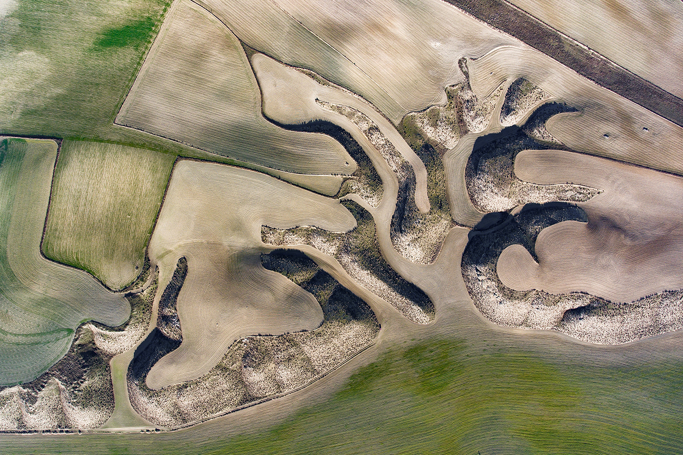
Wheat fields on hill slopes
Abstract pattern of wheat fields spreading through this hilly territory lit by last rays of sun in desert region of Aragon, thanks to the outlines of former wetlands. Near Botorrita village, Spain. December 30. 2018.
In Spain’s driest area, near Zaragoza, we may witness the struggle for water. Farmers cultivate the slopes, which are all that remain of a former wetland. Thus, the remnants of streams determine the shape of the farmlands. Not only is this soil more accessible, but more importantly, it is more productive and retains more moisture during the summer, helping the crops to grow. The main branch is criss-crossed with numerous stone barriers to protect from land erosion and to hold water on the fields as long as possible. By following this sound logic, farmers have created this amazing patterns, probably unaware of the amazing artistic formations as seen from above.
For more details, please visit
WATER.SHAPES.EARTH
© 2019 MIlan Radisics
milan@radex.hu

